
Best Motorcycle Rides in California 2026: 7 Expert-Vetted Routes (Post-Slide Reopening Update)
Updated: March 16, 2026

Looking for the best motorcycle rides in California in 2026? Whether you’re chasing the “flow state” on the Pacific Coast Highway or carving the technical desert hairpins of Westgard Pass, California offers the most diverse paved terrain in the country. Following the March 2026 reopening of Big Sur and recent storm-related closures on the Angeles Crest, staying updated on road conditions is as critical as your tire pressure. As lifelong enthusiasts who have scrubbed tires on every mile of this list, our team has vetted these top 7 California motorcycle routes for pavement quality, fuel logistics, and technical “fun factor.”
Below, you’ll find our 2026 field notes—complete with free Google Maps routes , verified GPX files for our Patreon community, and the specific “visual reveals” that make these roads great. From Northern California’s redwood-shaded sweepers to the high-alpine technicality near Los Angeles, these are the must-ride motorcycle roads every rider needs on their 2026 bucket list.
California Route Comparison
Use the table below to compare California’s best paved roads to ride a motorcycle.
| Route Name | Skill Level | Curve Profile | Best Months | Min. Fuel Range |
|---|---|---|---|---|
| Highway 1 (Big Sur) | Intermediate | Sweeping / Scenic | Sept–Oct | 80 Miles |
| Redwood Highway | Intermediate | Rhythmic Flowing Curves | May–Sept | 100 Miles |
| Westgard Pass | Advanced | Tight Technical Switchbacks | June–Sept | 30 Miles |
| Ortega Highway | Advanced | Technical Canyon Twisties | Oct–May | 50 Miles |
| Klamath River Hwy | Intermediate | Endless River-Follow Sweepers | May–Oct | 100 Miles |
| CA Route 33 | Advanced | Significant Elevation Changes | Oct–May | 100 Miles |
| Angeles Crest Hwy | Advanced | Technical Hairpins | May–Nov | 65 Miles |
California Motorcycle Routes Covered on This Page
- Highway 1 (Big Sur) – 90 miles of iconic cliffside sweepers and Pacific vistas.
- Redwood Highway – 192 miles of rhythmic flow through ancient forest cathedrals.
- Westgard Pass – 38 miles of remote, high-desert technical switchbacks.
- Ortega Highway – 25 miles of high-intensity canyon twisties and lean-angle logic.
- Klamath River Highway – 62 miles of low-traffic, river-carved sweepers and deep forest.
- CA Route 33 – 70 miles of epic alpine elevation changes and sweeping ridges.
- Angeles Crest Highway – 60 miles of legendary high-alpine curves and technical hairpins.

California Motorcycle Rides by Region
Join Us on YouTube!
See what it’s like to experience these great motorcycle rides in California. Join our 44K subscribers on YouTube today!
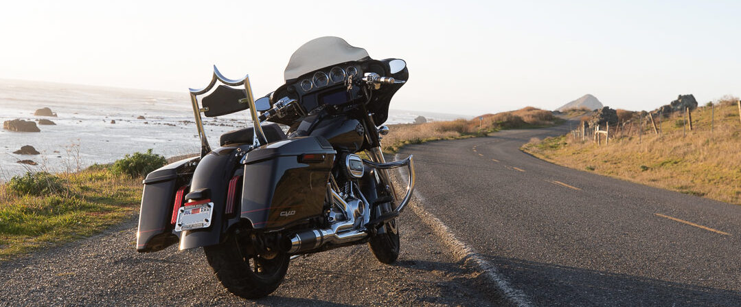
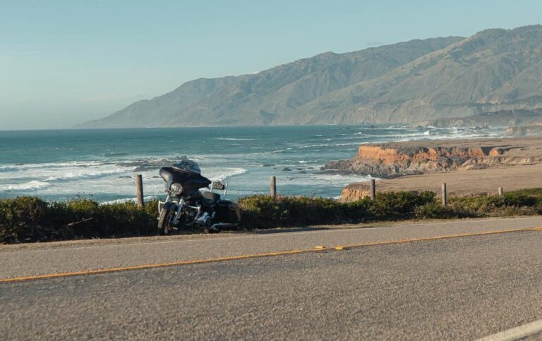
California Highway 1: The Pacific Coast Dream
- START/END: San Simeon to Carmel-by-the-Sea
- THE ROUTE: Highway 1
- TOTAL DISTANCE: 90 miles
- RIDE TIME: 3 hours
- TECHNICAL RATING: Intermediate to Advanced (Variable surface & vertical drops)
- BEST TIME: March-May
- GOOGLE MAPS: Ride link
- GPX FILE (PATREON MEMBERS): Download
California Highway 1 (Big Sur) is widely considered the best motorcycle road in California, featuring 71 miles of technical curves and iconic vistas like Bixby Bridge. Following the 2026 reopening of Regent’s Slide,
the route is now fully accessible from Carmel to San Simeon.
The Experience: What It’s Like to Ride
Riding Highway 1 by motorcycle is a sensory symphony. It’s the feeling of the salt air hitting your face and the temperature dropping as you dip into redwood-shaded canyons. The road has a natural, rhythmic “flow” that welcomes every style of rider. Whether you’re leaning into high-speed sweepers or just cruising at 45 mph to soak in the horizon, the road feels like it was engineered for two wheels. The pavement is generally smooth and predictable, but the real magic is the “dance”—the way the road mimics the coastline, making you feel completely connected to the machine and the landscape.
What You’ll See: The Visual Narrative
Highway 1 offers motorcyclists a series of breathtaking “reveals.” As you head north, you’ll crest Hurricane Point, where the vastness of the Pacific suddenly explodes into view, followed by the iconic concrete arch of Bixby Creek Bridge. You’ll ride past the hidden turquoise waters of McWay Falls, through the towering “cathedrals” of the Big Sur redwoods, and over rugged cliffs where the Santa Lucia Mountains meet the surf. Keep an eye out for elephant seals basking near San Simeon; it’s 90 miles of California’s most dramatic natural beauty.
Expert Planning Tips
- The Layering Rule: Even on a sunny 72°F day, the coastal fog can roll in, dropping temperatures to 55°F in an instant. Wear gear that can handle sudden shifts.
- Fuel Strategy: Services are sparse. Fill your tank in Cambria or Carmel. The “low fuel” light is a stressful companion on these cliffs.
- The Hidden Gem “Money Shot”: Bixby Creek Bridge is the iconic concrete arch. Don’t just stop at the main lookout. Cross the bridge heading north and use the small dirt pull-out on the right for the “hero shot” of your bike.
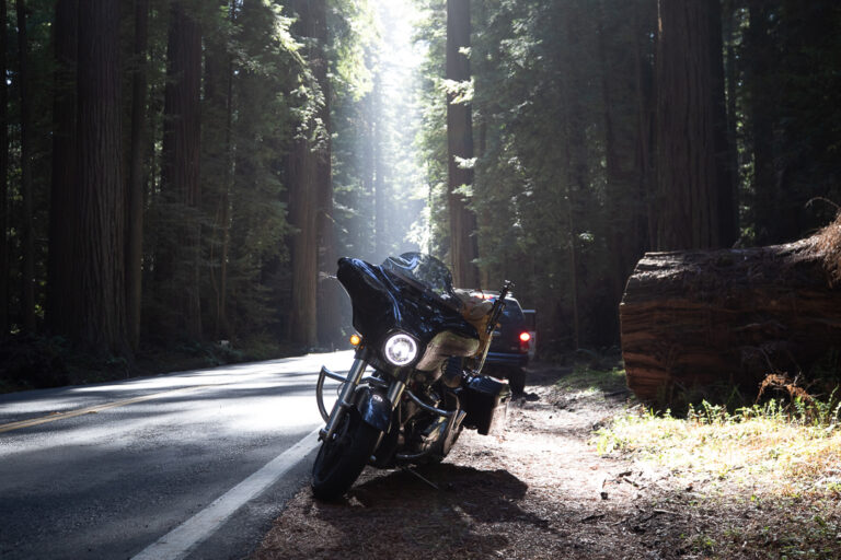
Redwood Highway: Nature’s Cathedral
- START/END: Leggett to Crescent City
- THE ROUTE: US-101 & Avenue of the Giants
- TOTAL DISTANCE: 192 miles
- RIDE TIME: 4 hours
- TECHNICAL RATING: Easy to Intermediate (Predictable sweepers)
- BEST TIME: May-Oct
- GOOGLE MAPS: Ride link
- GPX FILE (PATERON MEMBERS): Download
How often do you get a chance to ride among the largest trees on earth by motorcycle? The Redwood Highway stands out as one of the best motorcycle rides in California for shaded, serene cruising among the world’s tallest trees. This 192-mile gem winds through Northern California and delivers cool forest air even on hot days, making it a great motorcycle ride in the warmer months of the year.
The Experience: What It’s Like to Ride
Riding a motorcycle on the Redwood Highway feels like navigating a living tunnel. As you leave the heat of the interior and cross into the redwood belt, the temperature drops, and the air takes on a heavy, sweet scent of damp earth and fern. The motorcycle ride here is unique; the turns are often long, sweeping, and rhythmic, allowing you to maintain a steady pace as you travel between trunks that are wider than a lane of traffic.
What You’ll See: The Scale of Time
You aren’t just looking at trees; you’re riding through history. You’ll pass through the Avenue of the Giants, where the road narrows and the canopy blots out the sun, creating a strobe-light effect as you pass through beams of light. You’ll see the rugged, wild coastline of Del Norte County, where the forest literally crashes into the Pacific. Watch for the Roosevelt Elk in the meadows near Orick—they are massive, majestic, and a reminder that you are a guest in their territory. The “reveal” here happens near Klamath, where the road opens up to provide a panoramic view of the river meeting the sea. For longer touring, US-101 continues to be a great motorcycle ride in Oregon .
Expert Planning Tips
- The Temperature Gap: Expect a significant shift. It might be 85°F inland, but once you’re under the canopy near the coast, it can hover around 58°F with damp pavement. Keep a windproof layer handy to stay comfortable.
- Traction Awareness: Because the sun rarely hits the pavement in the densest groves, the road can stay damp long after rain. Watch for road debris—small redwood twigs or needles that can accumulate on the curves.
- Fuel and Logistics: While US-101 has more services than Highway 1, the gaps between Eureka and Crescent City can be deceptive. Don’t pass up a station in the smaller towns like Trinidad or Klamath.
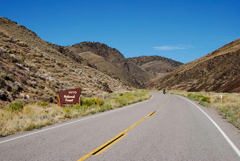
Westgard Pass: Best High-Desert Sierra Motorcycle Ride in California
- START/END: Big Pine to the Nevada State Line
- THE ROUTE: CA-168
- TOTAL DISTANCE: 38 miles
- RIDE TIME: 1 hour
- TECHNICAL RATING: Advanced (Tight canyon switchbacks with steep elevation changes)
- BEST TIME: Apr-June
- GOOGLE MAPS: Ride link
- GPX FILE (PATREON MEMBERS): Download
Moving east of the Sierras, we leave the lush forests behind for the high-desert drama of the Inyo Mountains. Westgard Pass is a hidden gem masterpiece that offers a sense of therapeutic isolation you just can’t find on the coast —the pavement snakes through narrow canyons and ancient bristlecone forests. Westgard Pass is a favorite for motorcyclists who crave a technical ride and the quiet majesty of the California desert’s towering peaks.
The Experience: What It’s Like to Ride
Riding Westgard Pass by motorcycle is a game of two halves. The climb out of Big Pine starts with a technical “canyon dance,” where the road is squeezed between sheer rock walls, forcing you to stay sharp on your lines and lean angles. As you gain elevation, the road opens up into high-speed, sweeping curves that offer a panoramic sense of scale. This section of CA-168 is especially exciting because of the rapid elevation gain—you’ll feel the bike’s power delivery change as the air thins. It’s a therapeutic ride because of the sheer emptiness; it’s often just you, your machine, and the wind echoing off the White Mountains.
What You’ll See: Ancient Horizons
The visual diversity on CA-168 is nothing short of stunning. You’ll start with views of the snow-capped Sierra Nevada in your mirrors before plunging into the narrow Big Pine Creek canyon. As you crest the pass, you’ll see the turn-off for the Ancient Bristlecone Pine Forest, home to the oldest living trees on Earth. The real “reveal” happens at the summit, where the road drops away to reveal the vast, shimmering expanse of Deep Springs Valley below—a view that looks like a painting from another century.
Expert Planning Tips
- The Altitude Factor: You’ll be climbing to over 7,300 feet. Even if it’s a blistering 90°F in Big Pine, the summit can be a crisp 65°F. Expect your bike to lose a little “punch” at the top due to the thinner air.
- The Desert Rule: This is remote territory. Cell service is non-existent once you enter the canyon.
- Fuel Strategy: There’s no fuel between Big Pine and Oasis (Nevada). Ensure you have a full tank before leaving the valley floor.
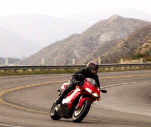
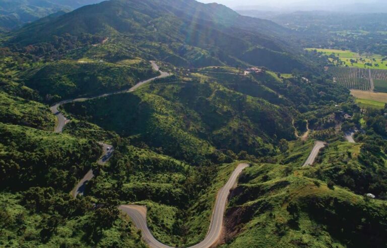
Ortega Highway: Southern California’s Twistiest Motorcycle Ride
- START/END: San Juan Capistrano to Lake Elsinore
- THE ROUTE: CA-74
- TOTAL DISTANCE: 25 miles
- RIDE TIME: 30 mins
- TECHNICAL RATING: Advanced (Tight corners)
- BEST TIME: Year-round
- GOOGLE MAPS: Ride link
- GPX FILE (PATREON MEMBERS): Download
Moving into Southern California, we hit a legendary ribbon of asphalt that has been a rite of passage for generations of California riders. The Ortega Highway (Hwy 74) offers a high-intensity blend of technical twisties and sweeping mountain vistas that balances technical intensity with some of the most accessible “fun factor” in the region.
The Experience: What It’s Like to Ride
Riding “The Ortega” on your motorcycle is an exercise in focus. The road is famous for its “rhythm sections”—stretches where the curves transition perfectly from left to right, allowing riders to find a deep “flow state” as you climb toward the summit. You’ll feel the bike work beneath you as the road gains elevation, moving from the coastal sea level up into the dry, sage-scented mountain air. It’s therapeutic because it demands your total attention; the proximity of the canyon walls and the lean angles required make the rest of the world fade away. When you hit the “S-turns” near the summit, you’ll understand why this is a local favorite.
What You’ll See: The Coast-to-Inland Reveal
The scenery is a beautiful mix of rugged canyon rock faces and expansive valley views. As you climb out of San Juan Capistrano, you’re surrounded by the lush greenery of the Cleveland National Forest. The highlight of the ride—the “visual reveal”—occurs at the Lookout Ranch, where the road suddenly crests to show a panoramic, bird’s-eye view of Lake Elsinore thousands of feet below. On a clear day, you can see the shimmering heat of the Inland Empire contrasting with the cool blue of the lake.
Expert Planning Tips
- Commuter Awareness: Avoid this road during weekday rush hours. It’s a major artery for commuters, and the “flow” is often broken by heavy traffic. Aim for mid-morning for the cleanest runs.
- The “Hell’s Kitchen” Stop: Make sure to pull over at one of the biker-friendly cafes at the summit. It’s the heartbeat of the local riding community and the best place to talk shop and admire other machines.
- Fuel & Temps: Temperatures can jump from a cool 68°F at the coast to a blistering 95°F in Lake Elsinore. There are plenty of fuel stops at both ends of the highway, but not much in the middle of the canyon.
EXPLORE MORE >>
Klamath River Highway: Northern California’s Best Riverside Sweepers
- START/END: Happy Camp to I-5
- THE ROUTE: CA-96
- TOTAL DISTANCE: 62 miles
- RIDE TIME: 1.5 hours
- TECHNICAL RATING: Intermediate to Advanced (Non-stop curve factor)
- BEST TIME: June-Sept
- GOOGLE MAPS: Ride link
- GPX FILE (PATREON MEMBERS): Download
Follow the emerald waters of the Klamath River on a 140-mile journey through a landscape of rugged canyons and dense forests. This is the road for the rider who wants to disappear—a low-traffic, high-reward route where the rhythm of the river dictates every lean and every apex.
The Experience: What It’s Like to Ride
Unlike mountain passes that climb and descend rapidly, this section of CA-96 maintains a steady, hypnotic altitude as it hugs the contours of the Klamath River. You’ll feel a unique centrifugal pull as you sweep through hundreds of medium-speed curves that never seem to end. The pavement is surprisingly good for such a remote area, but the real draw is the isolation—you can often ride for 30 minutes without seeing a single car. It’s a therapeutic experience that allows you to sync your breathing with the bike’s RPM as you shadow the water’s edge.
What You’ll See: The Wild Frontier
This is “Bigfoot Country.” You’ll ride through the heart of the Hoopa Valley and Karuk tribal lands, past steep moss-covered cliffs and massive rock outcroppings. The scenery is a deep, vibrant green, occasionally broken by the white water of the river’s rapids. The “visual reveal” here is the scale of the river itself; at several points, the road perches hundreds of feet above the water, offering views of eagles hunting in the canyons. In the fall, the maples turn a brilliant gold, reflecting off the dark water in a way that looks like a moving oil painting.

Expert Planning Tips
- The “Fuel-to-Fun” Warning: This is one of the most remote paved roads in California. Services are extremely limited. Fill up in Willow Creek or Hoopa. If your bike gets less than 40 mpg, don’t pass the small stations in Happy Camp—they are your only safety net before you hit the I-5 corridor.
- Surface Hazards: Because the road is carved into the canyon wall, watch for “rock-weep”—small pebbles or silt that can wash across the road after a rain or heavy wind. Always stay a foot or two away from the fog line on blind rights.
- Cell Service: Expect zero bars for the majority of this ride. This is a “pre-download your maps” route. Ensure your toolkit is packed and your tires are in top shape before heading in.
CA Route 33: Best Hidden Gem Motorcycle Road in California
- START/END: Ventura to Maricopa
- THE ROUTE: CA-33
- TOTAL DISTANCE: 70 miles
- RIDE TIME: 1.5 hours
- TECHNICAL RATING: Advanced (tight hairpins, significant elevation changes)
- BEST TIME: Oct-May (cooler temps)
- GOOGLE MAPS: Ride link
- GPX FILE (PATREON MEMBERS): Download
California Highway 33 (the Maricopa Highway) is a masterclass in road engineering. It’s legendary among Southern California enthusiasts for its immaculate pavement, dramatic tunnels, and a stretch of “S-turns” that feel like they were designed by a rider specifically for motorcycles. See below why CA-33 is a top-tier destination for anyone who wants to escape the coastal crowds and ascend into a geologic wonderland of sandstone canyons and high-pine ridges.
The Experience: What It’s Like to Ride
Riding CA-33 is an athletic experience. The climb out of Ojai is immediate and intense, requiring sharp trail-braking and precise gear selection as you navigate the narrow canyon walls. Once you pass through the iconic rock tunnels, the road opens into a high-speed “flow state” as you sweep across the face of the mountains. You’ll feel the temperature drop nearly 15°F as you crest the summit at over 5,000 feet. It’s therapeutic because of the transition—you start in a bustling town and, within 20 minutes, you are in a silent, high-altitude wilderness where the only sound is your exhaust echoing off the sandstone.
What You’ll See: The High Desert Fortress
The visual narrative of Highway 33 is one of raw, exposed geology. You’ll ride past the twisted sedimentary layers of Wheeler Gorge, through hand-blasted tunnels, and up onto the spine of Pine Mountain. The “visual reveal” here is breathtaking: as you reach the summit, the lush canyons of Ojai are replaced by the stark, vast beauty of the Cuyama Valley stretching out toward the horizon. The landscape looks more like the moon or the high Arizona desert than coastal California, with massive boulders and wind-swept pines lining the route.
Expert Planning Tips
- The “Fuel-to-Fun” Ratio: There’s not much by way of fuel stops once you leave Ojai until you reach the small outpost of Ventucopa (about 40 miles of hard riding). Be sure you’re topped off before you leave the valley floor.
- Rockfall Awareness: This road is carved out of crumbling sandstone. After a heavy wind or rain, keep on the lookout for small rocks in road, especially in the shadowed sections of the canyons.
Angeles Crest Highway: LA’s Ultimate Canyon Motorcycle Road
- START/END: I-210 to Wrightwood
- ROUTE: CA-2
- DISTANCE: 60 miles
- RIDE TIME: 1.5 hours
- TECHNICAL RATING: Advanced (Significant elevation changes and tight hairpins)
- BEST TIME: Year-round
- GOOGLE MAPS: Ride link
- GPX FILE (PATREON MEMBERS): Download
To round out our “Top 7,” we’re heading to the high-altitude crown jewel of the San Gabriel Mountains. The Angeles Crest Highway (CA-2) is a high-performance playground that offers a dramatic escape from the urban sprawl of Los Angeles. Rise above the clouds on one of the highest and most technical mountain roads in Southern California, reaching elevations that exceed 7,000 feet.
The Experience: What It’s Like to Ride
As you leave the heat and traffic of the LA basin, the crisp air becomes the first sign of the “therapeutic” shift to come. The Angeles Crest is famous for its “big-bore” sweepers—turns so wide and perfectly banked that you can settle into a deep, sustained lean for what feels like miles. You’ll feel the bike’s suspension work as you transition through the “S-curves” near Mount Wilson, moving from the urban haze into the thin, cool mountain oxygen. It’s a curvy motorcycle ride that demands respect and focus, rewarding you with a rhythmic flow that is unmatched in the SoCal region.
What You’ll See: Above the Haze
The visual narrative here is one of staggering scale. On a clear day, you’ll see the entire Los Angeles basin to your south and the vast, golden Mojave Desert to your north. You’ll ride through hand-carved tunnels and past granite faces that look like they belong in the High Sierras. The “visual reveal” happens at Cloudburst Summit, where the road crests at nearly 8,000 feet, offering a panoramic view of the rugged wilderness stretching toward the horizon. Keep an eye out for the historic Mount Wilson Observatory peering out from the ridges above.

Expert Planning Tips
- The Temperature Shift: This is a high-altitude environment. It can be a blistering 90°F at the base in La Cañada, but by the time you hit Newcomb’s Pass, it might be a brisk 65°F. Always carry a windproof layer or a vest to manage the “elevation chill.”
- Zero Fuel Zone: There are no gas stations on the mountain. You must fill your tank to the brim in La Cañada Flintridge.
- 2026 Partial Closure: A 27-mile stretch on the western side is closed indefinitely (as of early 2026). Specifically, you cannot ride through from Newcomb’s Ranch to Big Pines (Wrightwood).
LOOKING FOR MORE CALIFORNIA MOTORCYCLE RIDES?
Join us on Patreon to unlock these bonus features and more:
ROUTE PLANNING
Maps showing where routes are located within each US state.
GPX FILES
GPX files are available for download with each US motorcycle route.
EXCLUSIVE VIDEOS
Exclusive video content on the best motorcycle rides
MORE ROUTES
Bonus California motorcycle rides as well as more for US & Canada
Any bloggers or website articles that would like to use these routes, please refer to our
TERMS OF USE.
Please note: Any routes and recommendations are based solely on our opinions and are meant for informational purposes only. To use information contained on this site is to do so at your own risk. GreatMotorcycleRoads.com is not responsible for the information contained in these pages. We assume no liability for decisions made as a result of the information provided here. You are responsible for your decisions, your actions, and your safety. To use this website, you agree to our TERMS OF USE .

Frequently Asked Questions
Visit our friends at BikeWeekEvents.com to find local CA Motorcycle Rallies and all scheduled bike shows happening in California!
As one of the most popular tourist destinations in America, California draws a lot of motorcyclists from outside the state. Not only does California have great roads to discover, but there are also well-established motorcycle rental companies throughout the state. This enables out-of-state motorcyclists to fly in and rent a motorcycle instead of having to ride in.
According to California State law, all riders and passengers are required to wear a U.S. DOT compliant motorcycle safety helmet when riding a motorcycle, motor-driven cycle, or motorized bicycle. Read more here: dmv.ca.gov
– Pacific Coast Highway
– Ortega Highway (35 minutes from Orange County)
– Joshua Tree National Park (2 hours from Orange County)
To motorcycle the entire coastal CA Highway 1 would take 12-14 hours without stops. Of course, on a motorcycle, you will take many stops. Not only to refuel, but to take in the beautiful sights. Plan on a minimum of 3-5 days if getting a lot of miles in each day heading one way.

About the Author
Seth Profenna
Native to Northeastern United States, Seth Profenna has been following his passion for discovering the best roads to ride motorcycles for over 10 years.
Why this website?
GreatMotorcycleRoads.com has been created for like-minded riders who are looking for an easy-to-navigate source for the best motorcycle rides in America and around the world.
WHERE CAN I FIND SCENIC MOTORCYCLE ROUTES NEAR ME AROUND CALIFORNIA?
GreatMotorcycleRoads.com is the place to find the best motorcycle roads and rides near California and the Southwest United States. Discover more great motorcycle roads in the Southwest with our detailed route descriptions and Google Maps links!


